
Do You Want an 82 Foot Tall Tower in Kimball Junction?
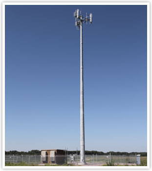
It appears Verizon Wireless is appealing to the Snyderville Basin Planning Commission for an 80+ foot tower behind Walmart. This will be a monopole type tower and will likely look something like this:
![]()
That’s a little over two and a half times the allowed upon height of a building in the Basin, but it is narrower, of course. I also suppose that if they allow this use, they should also let all the other major players do the same thing. So, that could eventually be 5 or 6 towers.
If this is something you feel passionately about, you may want to pencil the June 23rd Snyderville Basin Planning Commission Meeting into your calendar. It will be held at 6PM at the Kimball Junction Library building (Richens Building).
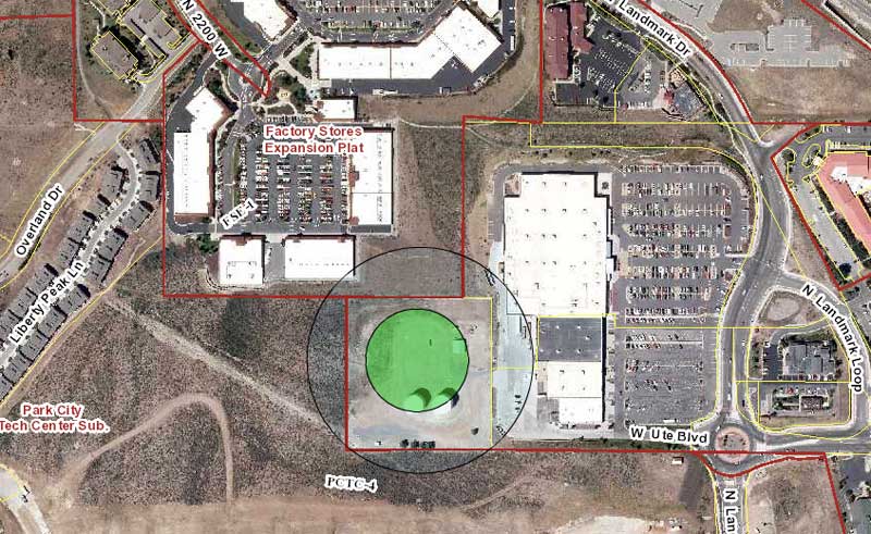
Here is the location of the proposed tower on land owned by Chevron:
Reader Question: Do You Really Want Houses Spread Across the Open Space on Highway 40
I received an email from a reader regarding a post from yesterday on the new proposed development south of Home Depot. He asked, “I think the idea of a whole bunch of houses out on the open space is horrible. Do you really think that is a good idea?”
I do think it is an alternative and the one the owner is currently entitled to by law. I think the first question is what we as citizens want for our community. That could be commercial growth in pockets around the Basin. That could also be no growth (probably not possible). It could be somewhere in between.
What I will say about residential development on this specific 450 acres is that there is a reason the owner wants to do something different than build houses. Could it be out of the goodness of the owner’s heart, who may want to ensure the best for the other residents of the Basin? Maybe. Could it be that they’d make more money by having a commercial component? Probably. Is it that it’s not economically viable as residential land? HMMM.
Let’s consider that last one. If the land owner went with their existing rights, they could build about 22 homes on the 455 acres. That’s 1 home per 20 acres. Now, what do you need to build a sub division? I can think of at least three things. You need sewer run to each house. You need a system of roads. You need to run utilities to each house. Keep in mind that the houses are likely to be spread out. This makes that infrastructure expensive.
To recoup your money, you’ll need to build expensive homes. But you’ll have to compete with Promontory, which is probably situated on superior land and still has lots available. You’ll also have to not price yourself out of the market. If you recall a few weeks ago, two local real estate professionals were on KPCW and said people were paying up to about $1.3 million on homes.
Is $28 million in home sales is enough to offset the expenses of building and marketing a subdivision? It seems right now the owner would rather take another course — one that includes commercial development. Would they even try to build homes there? Who knows (well the developer probably does).
If you don’t want development around the Basin, that’s the bet you are making by keeping it residential. You’re hoping that the economics don’t make any sense and that it will sit as open space for a while longer. That strategy doesn’t seem like a terrible gamble, in this instance, though.
Let’s Look At Growth in Summit County Historically
This morning on KPCW’s Local News Hour they were talking growth again. I heard there are 4,000 units of unbuilt density (basically homes) in Park City and about 14,000 in the Snyderville Basin. The theory presented is that because of those rights to build, that people are going to flock to the Park City area. The theory could turn out being right, and if so, that’s a lot of people to add to our area.
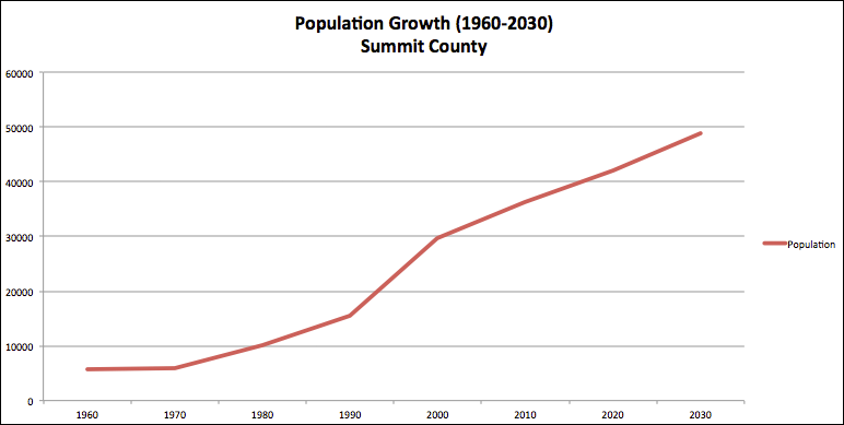
Yet, I started thinking about unbuilt density (homes). Weren’t most of those rights to build entitled for a long, long time? Perhaps, instead it makes sense to look at historical population trends and see what is happening in Summit County. Below is a chart of growth since 1960. It uses census data up to 2014 and then extrapolates the future based on the 2010 to 2014 average growth.
![]()
What you’ll see is that the greatest period of growth happened between 1990 and 2000 (92% growth). The second highest growth is 1970 to 1980 (73% growth). You’ll find that 2000-2010 actually ranks fourth in terms of growth (for decades since 1960), with 22% growth. There was only one lower growth decade, between 1960 and 1970 (4%). The results for 2000 to 2010, of course, may have been influenced by the Great Recession. Yet, what has it looked like this decade?
If we extrapolate out the growth we have seen so far this decade, we are at 16% growth for the 2010 to to 2020 period. However, the country hasn’t had a recession since 2009. That is historically unprecedented and therefore its likely there will be a recession in the next five years. Thus, since population growth often slows related to recessions, it is likely this decade will see even less growth than what I extrapolated. It will likely have the slowest growth of any time since 1970.
So what does that tell us? Growth is likely less now than in decades, on a percentage basis (you could also look at a raw population basis, which I’ll try to do later). What we have to ask is if availability of homes drive people to move here (i.e., damn the growth trends, if we build it they will come) or whether populations grow and then they need homes (i.e., it’s the people that want to live here and not the property that matters). I wish I was smart enough to know which it was.
Yet I keep coming back to the fact that a lot of this land was available for homes for a long time. Is it just that the “right” population wasn’t available to move here (or didn’t want to move here) and thus it wasn’t developed? Is there some other factor that has limited building of homes? Perhaps.
Regardless, I think it makes sense to consider population trends as a large factor into our population models that drive political decision in and around Park City. Given those trends maybe we don’t need to rush to convert land to commercial centers to pack in density. Maybe we let land ride as residential (which a lot of it is) and see if what’s past is prologue.
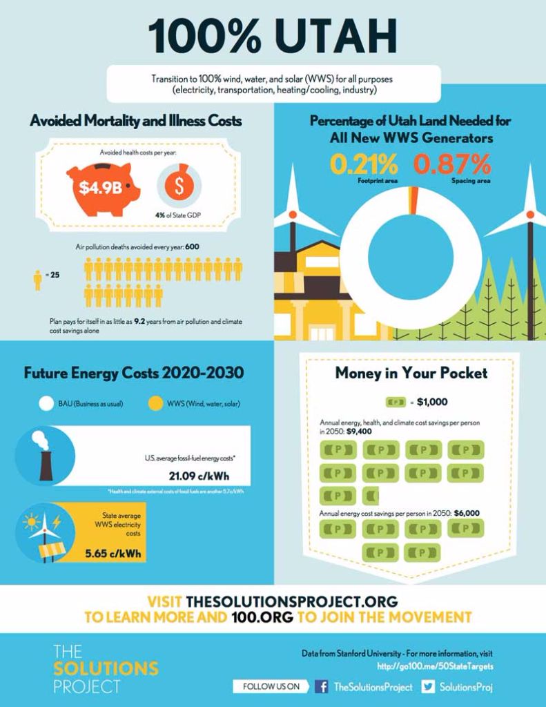
100% Renewable Sourced Energy in Utah
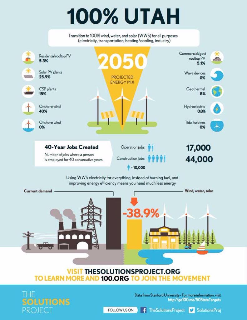
The Solutions Project has an interesting graphic that talks about how each state could shift to 100% renewable energy by 2050. It’s an interesting experiment to think of something so daunting and break it down into how to accomplish it and the benefits of doing so.
Here is Utah’s breakdown:
Do We View Commercial Sprawl and Residential Sprawl Equally?
People concerned with the design of our cities often use the word urban sprawl. Urban sprawl or suburban sprawl “describes the expansion of human populations away from central urban areas into low-density, monofunctional and usually car-dependent communities” according to Wikipedia.
There is the concern that urban sprawl is coming to the Snyderville Basin (if it isn’t already here). I often hear the rhetorical question, “do you want every single piece of land filled up in the Basin?” Of course not. Yet, when reading through a proposed development called Pace Meadows, which is 450 acres to the south and east of Home Depot, I started thinking about urban sprawl.
What the Pace Meadows land owners want is a mixed commercial/residential area on approximately 45 acres of their land. Right now they only have the right to build homes. On their 450 acres they could put 22 homes (1 home per 20 acres). This sets up the question of whether we as citizens would rather see 20 homes out on the prairie (I envision is looking something like Promentory) or whether we’d like to see a mixed commercial area with a grocery store, restaurants, bars, houses, etc. packed into 45 acres.
It makes me wonder whether residential sprawl, in this case, is preferable to commercial sprawl.
Past pure aesthetics, we also have to consider the traffic component of sprawl. The question is will a development like this, which has a strong public transportation focus, limit people from driving their cars? I suppose that depends on what percentage of people will take the bus. We’d need them to ride the bus to work in Park City and Salt Lake. We’d need their kids to ride the bus to Kamas or Heber (this is in the South Summit School District). We’d need them to ride to other places to shop (like if they wanted to go to one of the other grocery stores in town).
We’d need far more ridership out of this area than the average we see even in Salt Lake (5.8% of people in Salt Lake ride public transportation according to the census). Do we envision that? Could we restrict this area to one car garages and driveways? Could we tax parking to ensure that every hour of parking costs $30? Would the land owners even want to continue forward if those were the rules?
I understand that the Basin is full of unbuilt density. Yet, a huge amount of it is 1 home per 20 acre residential zoning. I’m starting to wonder if building that out is preferable in most cases to commercial development. If we are going to sprawl, would we rather have pockets of tight mixed residential/commercial activity or would we rather have homes dotted across the land.
I think that is one of the fundamental questions that we, the citizens of the Snyderville Basin, need to ask ourselves.
Proposed Development Next to Home Depot Highlights Choices We Have to Make
You may have heard of the 1200 units being developed close to Home Depot as part of Silver Creek Village. Well, there is more coming. A developer is now proposing a mix of houses and commercial businesses on the south side of Home Depot too. The developer wants to add a new development zone to our development code so they can build a mix of houses, affordable housing, a grocery store, and other commercial entities on roughly 46 acres of the 460 acre land (the rest would become open space). The rub is that the land is currently zoned for 1 house per 20 acres and nothing commercial.
This is an interesting development because it highlights the choices we as a community have to make as growth occurs and land owners want to maximize their opportunities. With that in mind, here are four choices along the spectrum of options that we as a community could make. Do any of these sound good?
- The Bet: We could tell the land owner that the property is going to stay zoned as is (for homes). The land owner would likely say fine, “then I’ll build 20 mansions on the property,” which the owner can do with their existing development rights. The counter argument to the land owner might be, “well if you were going to do that, then you would have done that already.” The question is whether the owner would go ahead an build only homes or whether they would leave it as psuedo-open space and hope for a better outcome later. If you thought they may wait, and you don’t want the development, this might be a good strategy.
- The Bargain: We could bargain with the owner and say that the County would prefer that this land stay open space. We’d need to give him something in return that would be as equal or more in value. Perhaps, that would be a rezone of another part of the Basin. An example would be the hill at the entrance to Jeremy Ranch or the Bitner property by the Bells gas station. In effect we are trying to prevent sprawl by choosing choice locations for development. This is what the Planning Department was looking at last year and would require some sort of ability (in our code) to transfer development rights. The downside of this, to many people, is that it impacts the existing neighborhood they live in. Would you save the Highway 40 corridor by giving a little bit of your neighborhood?
- The Concession: We could let the owner do what they want and create a new zone to support their development. This would gain the citizens of Basin about 400 acres of open space along Highway 40. The downside is that it would create sprawl in one of the hot button areas in the Basin (the Highway 40 corridor). The proposed plans include the ability to have everything from a funeral home to a hotel on the property.
- The All In: We could make the area a Town Center (like Kimball Junction). We could work with the developer to make what we envision is the “perfect” area — a self contained development with restaurants, groceries, homes, and businesses all focused around public transportation. Summit County owns the parcel of land next door (the triangle parcel), so we could build whatever transportation hub is necessary. This idea, of course, essentially cedes the Highway 40 to become the new Sandy. But perhaps better here than in your neighborhood.
There are countless other possible plans. Yet, hopefully the four above highlight the challenges. Something is going to happen on that land (and the rest of the Highway 40 corridor). Do you want to try and slow things down and hope that something happens? Are you willing to sacrifice your neighborhood for Highway 40? Should we go all in and try our hand at real master planning?
I’m not sure yet. Tonight the Snyderville Basin Planning Commission is meeting to discuss this very item. It should be interesting to get their initial impressions on the issue.
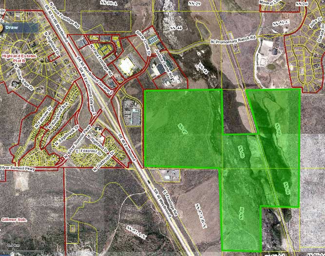
Area in Green is the proposed development
Do Our Local Governments Approach Housing With too Broad of a Brush?
This morning I read a Wall Street Journal Article entitled, New Housing Crisis Looms as Fewer Renters Can Afford to Own. The author’s main point is that “Last decade’s housing crisis has given way to a new one in which many families lack the incomes or savings needed to buy homes, creating a surge of renters and a shortage of affordable housing.” Yet, the details he presents makes me wonder if we in Summit County and Park City are approaching the affordable housing issue at too high of a level, with insufficient detail.
Some of the information the author introduces includes:
- The U.S. homeownership rate is now below where it stood 20 years ago when President Bill Clinton launched a national campaign to encourage more Americans to buy homes.
- The declines [in home ownership] reflect a surge of new renter households, which is boosting rents. Together with tougher mortgage-qualification rules, this will leave households stuck between homes they can’t qualify to purchase and rentals they can’t afford
- The Urban Institute researchers predict that more than 3 in 4 new households this decade, and 7 of 8 in the next, will be formed by minorities.
- Nearly half of those households will be Hispanic—have lower incomes, less wealth and lower homeownership rates than the U.S. average.
It’s true that Park City isn’t an average location when looking at homes. Yet, as I read the article I thought back to how many times I heard the words “affordable housing” when attending Summit County Council and Park City City Council meetings. After reading this article, I began to wonder what the term even means.
When we say affordable housing, what are we referring to? Is it a $400,000 house, which takes a family income of about $100,000 to be able to afford the mortgage. Is it a $700,000 studio on Main Street? Does it mean a 900 square foot condo in Snyderville Basin that may cost $325,000? Does it mean apartments for rent with 12 month leases (that don’t really meet the seasonal worker need)? Is it something we haven’t seen yet where affordable rentals are restricted somehow to require the option of very short-term leases?
Then I wonder who they think will be using the “affordable” housing. Are they seasonal employees? Are they people who want to move out of the valley? Are they young professionals? Are they middle aged artists? Are they established families? Are they college aged kids who grew up here?
There is just so much to it that I never have contemplated. It’s like saying, “let’s solve transportation” without knowing exactly what the issues are and what’s trying to be accomplished. You lash out with a solution because it sounds good but you’ll be lucky if you hit the broad side of the barn (or the problem).
The next time I hear that we need affordable housing, without any detail provided, I’m not going to take it at face value. I want the details. I want to know exactly what demographic we are trying to serve and how we are going to serve it. Without that, all we are doing is investing time and resources in something that has little likelihood of success… just because it sounds good.
To me it is starting to sound like when people talk about growth. They’ll tell you “growth is coming.” I always wonder if that growth is 50,000 multi-millionaires or 50,000 ski bums. In this case, we likely do need affordable housing, but exactly what demographics are we expecting, and have we accounted for the changing landscape of today’s home buyer and renter.
Vail Earnings to Be Released Monday
With Vail now being such a large part of our community, you may want to listen to Monday’s company earnings call. Last quarter I learned that Vail does not actually forecast the number of visitors to its resorts. It forecasts the money made.
So when Vail told Park City and Summit that they didn’t know if combining the Canyons and PCMR resorts would increase visitors, they were being genuine.
It should be interesting to hear about current plans for combining resorts, how the dry winter impacted them, and what they are focusing on for the future.
That call is Monday at 9:30 AM MT. If interested, go to www.vailresorts.com and they say the live audio will be available under the investors section.
More on Blyncsy And Privacy
Related to a previous piece on cell phone monitoring for traffic, a reader asked for a picture of the Blyncsy sensor (the device tracking your cell phone) and where they were located. I have put those at the bottom of this post.
I’m glad there is some interest on this topic. Given that, I think there is a little more to say about Blyncsy and privacy. There is always a tradeoff with privacy. I use Gmail every day and per the terms of the user agreement that gives Google the right to use my information to sell to advertisers. As they say, I AM THE PRODUCT being sold. I don’t like the sound of that but with Gmail I get paid back by having free email that runs virtually 100% of the time. I have traded privacy for convenience.
With Blyncsy, again I AM THE PRODUCT being sold. In this case Blyncsy is selling me to Park City (and maybe eventually Vail and Deer Valley). They know where I am and sell that data to Park City. Yet unlike Gmail I don’t know that I value the tradeoff. In the case of Gmail, they know who emails me and the topic of emails and in return I get a great service. In the case of Blyncsy, they know where I go and I get…I’m not exactly sure .. maybe comfort knowing that Park City someday will use a system like this to shorten my drive time on a POW day…somehow? Perhaps more importantly, I have concerns over the business transaction. Park City paid $15,000 for this pilot yet I don’t trust the information is going to be accurate or even work.
When I visited with Mark Pittman, CEO of Blyncsy, I asked a question from a citizen about how they handle people riding buses (they don’t currently filter out bus rides according to Mark). If you think about it, there are up to 100 people on a bus headed from Kimball Junction to Main Street. If Blyncsy is just tracking signals, does that look like 100 cars headed to Main Street?If I’m driving down Kearns with my wife and kids, the signals produced from my car would be my iPhone, my wife’s phone, the iPad in my bag, my car’s bluetooth signal, and my Pebble watch. Is that 1 car impacting traffic on Main or is that 5 cars? Perhaps they have that problem figured out and managed, but it didn’t sound like it.
So, if I’m trading my privacy to FIX traffic problems in Park City, I may be in favor of it. If I’m trading my privacy for a system that will provide little benefit to me, then why would I ever do that? Perhaps more importantly, you have to realize that I didn’t trade my privacy. Park City traded my privacy. Ugggh.
Let me interrupt to say that I love new technology. Conceptually, I like the idea of a small startup working on a problem to help transportation issues. I told Blyncsy’s CEO that I thought technically what they were doing was very cool. Yet, in the real world, I wish they would have found a different way to fix transportation.
I’m left feeling a little violated. Park City traded my right to privacy for a “cool” software tool that seems to have giant hurdles before it will actually provide value. I know I can opt out, but that leaves me both trusting the company that they follow through on the opt out and forcing me to opt out so my privacy isn’t violated.
In today’s world, maintaining privacy is all about trade offs, but I have a hard time understanding what I am actually getting here.
The sensor that tracks you:
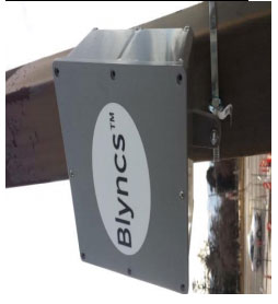
![]()
Where those sensors are:
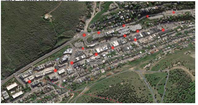
![]()
Note: There are only 15 monitors listed on this image. There should be 8 others somewhere.
Is Your Privacy Dead? An Interview with Blyncsy’s CEO.
You may remember an earlier post on Blyncsy, the company that has installed cell phone sensors around Park City in order to help monitor traffic. I raised privacy concerns over the capture of cell phone signals and had the chance to chat with Mark Pittman, the CEO of Blyncsy today about those concerns. I was able to ask questions regarding privacy, as well as those submitted by the broader community.
My conclusion after the call is that Mr Pittman seems to be a very nice and genuine individual. Blyncsy seems to have considered privacy and have tried to incorporate that what they are doing. That said, the fundamental nature of what they are doing will likely be viewed as “creepy” (as one reader put it) by some. People who are against a third party collecting any information on them will likely be very disturbed by this. And the majority of people probably just won’t care.
So, what are some examples of how this information could be used to invade privacy? Here are a couple of examples:
- Perhaps you are in a nasty divorce and your spouse has cheated on you. Your lawyer convinces a judge to create a request for Blyncsy to produce documents detailing your spouse’s location through town during the last 2 years. Blyncsy would likely be forced to comply and tell the court where you drove around town, how long you stopped, etc. You could extrapolate that example in a number of different ways.
- Perhaps you want to dig up dirt on someone. You find the person’s phone MAC address. You then pay someone with access to the Blyncsy database or find a way in to it. Though this is highly illegal, since the information exists it becomes a target. Think of the extent paparazzi go to to follow and take pictures of celebrities. This isn’t that different.
These examples rely on getting someone’s MAC address from their phone. The MAC address is a unique identifier for a phone’s WIFI and Bluetooth operations (two different addresses usually). They are unique in the world and perfectly identify your phone. Mr Pittman spoke of the MAC address as if it was purely anonymous. The problem is that it isn’t completely anonymous. I mentioned in my previous article that I would explain how to get the MAC address of someone like the Mayor. Effectively you would use readily available software programs to see what MAC addresses were being used during a City Council Meeting. You’d then happen to show up at a coffee shop where the Mayor is and see what MAC addresses were being used. Cross reference the two lists and the anonymity is gone.
Is that a little unlikely? Yes but so is having two candidates each spending $50,000 on an election for the Mayor of Park City. You just never know. And that’s the problem with protecting privacy. Once you give someone the ability to track you via sensors, then your privacy is gone. The only question is how is someone going to use your information.
You may not care about this at all, and I can see that. You may care a lot, and that makes total sense to me too. The problem is that your data is being scooped up and stored by a third party. Your only protection is your trust in Blyncsy and what they say. That’s true, even if you fill out their opt out form. In some ways Park City has enabled a process that requires absolute faith.
That’s a bit strange to find in Park City.
Here are the questions and the gist of Mr Pittman’s responses:
Park Rag: What does Blyncsy’s system do?
Mr Pittman: Blyncsy enables real-time traffic studies. They use WI-FI and Bluetooth signals from cell phones, watches, tablet, cars, etc. to be able to tell what is passing by the sensor. Blyncsy turns people’s cell phones into actionable information by city personnel.
Park Rag: How many sensors will Blyncsy have around Park City.
Mr Pittman: In the near future there will be 23.
Park Rag: How is privacy protected by Blyncsy?
Mr Pittman: Park City never sees individual people’s information. City personnel log into a dashboard and see information that lets them make transportation decisions based on aggregate data. There is no personally identifiable information like names or phone numbers transmitted. There is only the device’s MAC address (Machine address) for the phone transmitted. In addition, Blyncsy just created a privacy policy and has an opt out page.
Park Rag: How does that opt out page work?
Mr Pittman: People enter their name, device information, and agree to be excluded.
Park Rag: What happens then?
Mr Pittman: Blyncsy will delete the MAC address data from its database each time it is received.
Park Rag: Is there anything else than can be done?
Mr Pittman: A person could turn off bluetooth and WI-FI on their cell phone and tablets. However, people should also realize the potential long term benefits from this traffic data. If they opt out or turn off wireless, then Blyncsy can’t help Park City incorporate their data into analyses. Also, in the future things like traffic lights may automatically be controlled by Blyncsy, and if a person isn’t included, they may not influence things like the traffic signals to their benefit.
Park Rag (from citizen question): Does law enforcement have access to this information?
Mr Pittman: The contract with Park City says they cannot request individuals’ data. That means that law enforcement could not either. Mr Pitman did clarify that if a federal judge ordered them to reveal the information they would. In that case, Blyncsy would do everything in their power to notify the person who was the subject of the request.
Park Rag (from citizen question): How does Blyncsy account for people on buses, cyclists, and bikers?
Mr Pittman: Blyncsy can use speed and other statistics to filter out people moving slowly. Right now, bus data is not removed or filtered out, but it should be possible to do in the future. In the future they may want to work with UTA to provide data about riders.
Park Rag (from citizen question): How long is data stored?
Mr Pittman: It is stored indefinitely. Park City may want to incorporate previous years information into analyses.
Park Rag (from citizen question): Is data ever sold?
Mr Pittman: Not right now. Mr Pittman says that in the future they may try to help businesses better understand their customers.
Parkrag
We believe in citizen journalism. We believe there are stories to tell that can help to shape our community for the better. We believe tomorrow's Park City can be better than today's.