The Couple from Michigan Who Will Probably Never Ride Park City Buses Again
We decided we should spend some time riding Park City Buses, if we were going to understand what’s working and what’s not with our transit system. We headed to the bus stop in Kimball Junction by Silver Mountain to await our 2:53 PM pickup (the bus was a bit late). A nice couple from Michigan was already waiting. They said hi and we asked how the skiing had been on their trip. They replied that it was nice on the top of the mountain but down low was pretty slushy; overall they had never skied in such nice weather though (great attitude!).
As the bus pulled up, they asked us if this bus would take them to Main Street. They wanted to go shop and have dinner. It was a “7 Pink” bus pulling up, so we responded that it would eventually get to Main Street, but there could be a better option. So we said they should ask the bus driver. We could have replied, “Well you should download My Stop Mobile, Park City’s $1.2 million application from the Apple App store” but there isn’t really time for that when the bus is pulling up.
When asked by the couple, the bus driver replied, “oh no… you should take the Brown bus line”. The couple got off the bus and headed back to wait. The bus drove off, and as we looked at the couple sitting there, we wondered how long would they wait. It turns out that they would have plenty of time to download the MyStop Mobile App.
We looked up bus transportation data and it told us that if they would have taken the 7 Pink, they would have gotten to Main Street at 4:45. Granted, that is almost an hour later (ugh). However, if they waited on the Brown bus, they waited until 4:51 for it to pick them up and it wouldn’t have dropped them off until 5:17 (double ugh). Oh, and that same 7 Pink bus even came back through the same stop. So, hopefully they got wise and just hopped on it.
What is more likely is that they hopped in their car and drove to Main Street.
Now, is this just an anecdote? Sure. In this case were the buses running late? Yes. Does this happen all the time? We don’t know.
What we are sure of is that public transportation failed this couple. It also highlights the inherent problem with our public transportation system. The buses are scheduled too far apart and when something goes wrong (like being late), it causes a huge impact. Then, if we think about the times when buses are late due to heavy traffic (special events, big snow, rush hour, etc.) it’s also the same time we want more people to take the buses. So, the times we need buses are likely the times they fail.
So, you may say that we should run the buses more frequently. However, that requires that the demand is there to justify it. We’ve been looking at the ridership data, and except on a few key routes between PCMR and Deer Valley, it seems really low. We will share some of that data as soon as we have enough information to draw a full picture.
It also highlights a technological problem. Given that Park City has invested so much in an automated system to track buses, this information should be shared with their drivers. A bus driver should be able to easily pull up a screen with popular destinations, and then the system could use their current location and real-time data to enable the driver to tell that poor couple from Michigan, “normally you’d take the 8 Brown bus but today you should ride with me. We may be taking the scenic route but its the fastest way to get there and you’ll see a lot of what makes Park City great.”
Instead, the couple likely headed to Wendy’s to get a Frosty for their car drive in.
Which has less pollution … bus or car? You may be surprised.
Yesterday we linked to a study that suggested that light rail pollutes our environment less than buses. However, what we read today is a little more interesting. The Reason Foundation has published an article about greenhouse gas emissions and whether buses are superior to cars.
Like us initially, you probably believe buses are far superior. A study from Duke University backs up that idea with the conclusion that less greenhouse gases are produced by buses than cars. The only issue is that they calculated the optimal solution based buses being 63% full. In reality, most buses are far less full. The conclusion that the Reason article draws, is that in the real world, based on real-world ridership and occupancy of cars, people riding in cars typically produce less greenhouse gases because buses have very low ridership (as a whole).
Why this matters around Park City is that we are trying to plan our future transportation needs. Right now we are focused on how long it takes to get from Point A to Point B and buses seem to be the only feasible solution to that. However, greenhouse gases are an equally troubling issue. We don’t want the valley inversion to spread here.
So, in Park City are buses better for both traffic and the environment? We suppose that depends on what percentage of buses are full. We are looking into that and should have data shortly.
For now we are left wondering if it ends up being a battle between air quality and traffic. If it does, which do you care about more?
Are you willing to send your children to war?
At the Park Rag, we rarely touch state issues, let alone national or global issues. Yet, this morning we saw an NBC/Maris poll that stated two-thirds of Americans think we should send troops to defeat ISIS (the Islamic group in Syria and Iraq). President Obama has thus requested Congress to formally approve military intervention against ISIS. We are currently launching air strikes against ISIS so this likely means an escalation to boots on the ground.
This is a big deal. Lest we forget recent confrontations in Afghanistan or we forget recent confrontations in Iraq or even go back to the 1970’s and Vietnam, 5 years on things often morph into something larger than expected.
Often times we think there are no personal impacts. Yet, you can never be sure of that once a war formally begins. Our new Summit County Manager is in the National Guard. Could he be called to active duty? Sure.
While the population of the Snyderville Basin doesn’t typically lend itself to a military life and this scene from Family Guy is too close to reality…
… someone’s children will be fighting this war.
Now, you may believe that another war is worth it, that ISIS must be stopped, and that is fine. Everyone has their own opinion. What we ask is that you form an opinion and please let your congress person know.
Our fear is that we are repeating the mistakes of the past. This time, we have an opportunity to learn from those mistakes and decide whether you are willing to give up your child in order to stop whatever threat ISIS presents. Maybe it is important enough to you that you are willing to pay that sacrifice. If so, then you should let Orrin Hatch, Mike Lee, and Rob Bishop know. If not, you should really let them know.
Should We Try to Limit House Sizes Around Park City
Recently there has been quite the uproar over transportation and now there is an attempt to “solve the problem” of people driving in their cars. Should we make parking so expensive that no one will want to drive? Should we limit the cars that can come into Park City? Should we get rid of parking and make it painful to drive anywhere? To borrow from an awful 1980’s Sylvester Stallone movie, it’s seems “Driving is a Disease and the Government is the cure.”
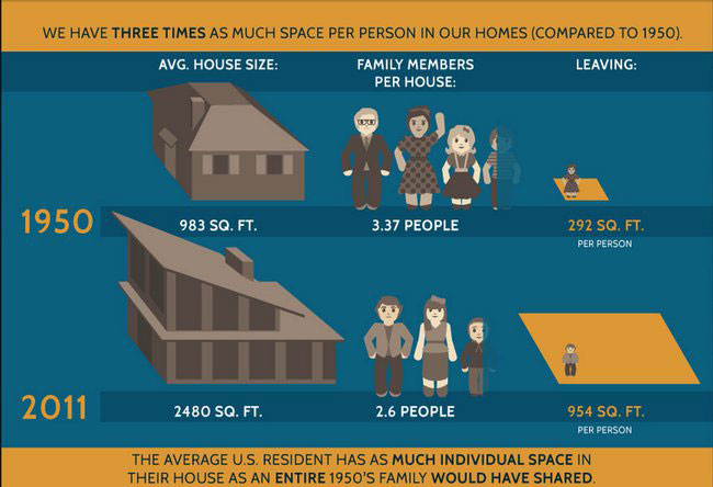
If we are willing to make arbitrary rules, how about one on house size for new homes? Smaller homes could lead to less people. Less people could lead to less cars. Less cars could lead to less traffic? There are also ancillary benefits like less electricity required and less natural gas.
Here is a graphic on the average house size nationwide:
What do you think the average home size is in the Snyderville Basin? 3,000 sq ft? 4,000 sq ft? More?
Are we serious with a question like this? No, not really. It seems to be a serious infringement on rights. That said, are the ideas that are being thrown around for cars any less of an infringement?
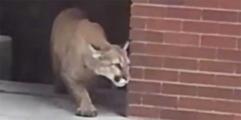
Jeremy Ranch Mountain Lion
If you live around Jeremy Ranch, we are getting reports from residents that a mountain lion seems to be hanging around the hill across the LDS church. So, if you have dogs or small children you may want to take that into account.
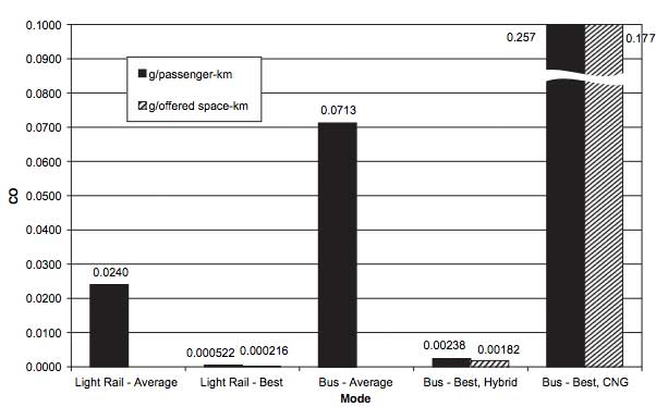
Bus Versus Light Rail… Which Creates More Polution?
This morning on KPCW, Summit County Council member Claudia McMullin spoke about the Health Department wanting wood fireplaces banned in new construction as well as her preference for light rail (over buses) at a high level.
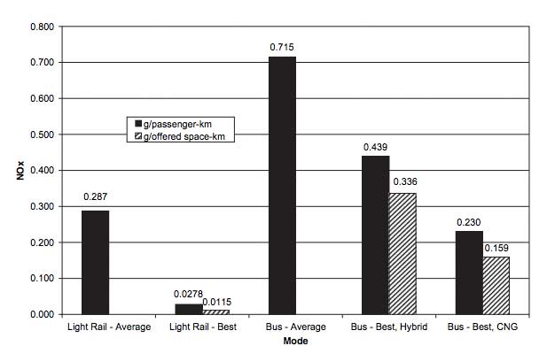
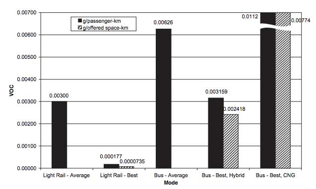
This got us wondering about the pollution impacts of buses versus light rail. Fortunately for us, Maryland’s Action Committee for Transit, published a study on the subject. The study’s results show, “that although advances in diesel technology have radically improved bus emissions, LRT (Light Rail) systems still produce less regional or urban emissions in the three categories considered than BRT (Bus Rapid Transit) systems. This is true whenever equal technology levels are compared and even when superior BRT technology is compared with standard LRT systems for some pollutants. In addition, emissions of both modes have improved over time. These results are only applicable to the effects of these technologies on regional air quality and not on street-level air quality or emissions on a national or global scale.”
NOx Comparison:
VOC Comparison:
If this topic interests you, you may want to check out the entire results:
http://www.actfortransit.org/docs/2008JulLRTvsBRTemmissions.pdf
County Considering Expanding Allowed Uses and Square Footage at Old Meacham Jeep Site
On February 25th, the Summit County Council will hold a public hearing to discuss increasing the types of uses and the amount of square footage that is available at the old Meacham Jeep site. Meacham Jeep’s site is now occupied by Professional Care Auto Works and sits on the east edge of the Burt Brothers facility.
Since this is a public hearing, the county would like to hear from you if you have an opinion. Some reasons you may be FOR this proposal include:
- This will allow potentially more types of businesses, that could be more successful. This would provide more tax dollars to our community.
- Since this is a commercial area, many people feel the owner should be able to do whatever he wants with the property.
- The area has changed dramatically since the Jeep Dealership was there. You may think that the old rules should no longer apply.
Some reasons you may be AGAINST this would be:
- If this building is a successful, there will be more traffic on Rasmussen Rd … which is two lanes and isn’t equipped to handle more traffic.
- There is a daycare in the Burt Brothers area already. Expanding traffic could endanger children.
- More traffic along Rasmussen, so close to the new trail that was built along the road, could endanger trail users.
One interesting thing we found is a street view of this area from 2007. It’s amazing how much it has already changed (and probably for the better). You can click around the image below and see what the area used to look like.
If you have a strong feeling either way about this area, you should let the Summit County Council know. We’ll provide an update when we hear more about proposed details.
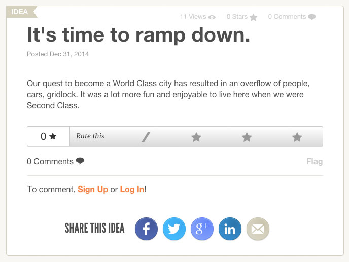
We are hearing this more and more…
Park City has a website called “Let’s Talk Park City.” People can go there and list ideas they have for the town. This idea was listed a couple of months ago but it sums up a view that we’re hearing a lot recently…
When They Build It Will You Come?
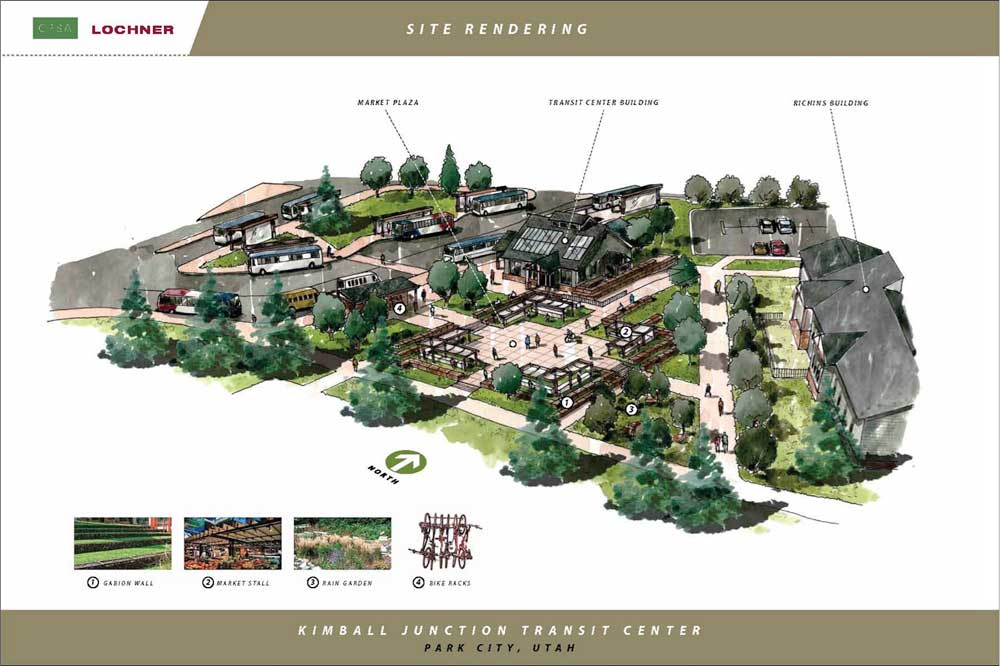
On Wednesday, the Summit County Council will be reviewing a design for a bus transit center that occupies 3 acres behind the Richins Library building in Kimball Junction. The project, in development since 2010, aims to realign county bus routes for better efficiency, provide a “circulator” service around Kimball Junction, and provide expanded opportunities for regional transit services.
The proposed transit center has 10 spaces for buses, 2 spaces for vans, 20 parking spaces for cars, a 2500 sq foot customer service building (restrooms, info booth, etc.), and bike storage. This what the proposed facility will look like:
It’s a nice looking building and seems to complement the Richin’s Building nicely. It also appears to be a done deal. According to a Summit County presentation on the topic, “the Design [was] Reviewed and Approved by PC Transit. PC Transit Applied for a $1.7M Grant from FTA and an award was made in 2014. County Council Approved $500K for construction. PC Transit also rearranged FTA Monies for Design and Summit County Received a check for $95,000.”
Yet, is this just another case where we build something and spend taxpayer money with the hope that it will somehow do something? We’re not sure, but we do believe it’s another case of where hopes and wishes have trumped the real world. Here are our questions and concerns:
- From county documents, it sounds like they don’t want many people driving in and parking and using this as a park and ride (only 20 park and ride spaces). If they did, it would only contribute to additional traffic on 224. So, how will it be used? Most likely as a transfer station. Isn’t that sort of what the area by Newpark Hotel already does?
- Creating a base for buses that would circle around Kimball Junction is another stated goal. Again, that sounds good but what population will use this? We envision the idea is that people will ride around Kimball Village shopping and dining. However, what does that really look like? People would need to ride a bus from wherever they are to the new transit station. They would then get on the circulator bus. They would stop at Smith’s and do their shopping. They would have 3 or 4 bags of groceries. They would ride to PetCo and pick up their 30 pounds of dog food. They may stop off for lunch after that at Zuppas. They may then hit Best Buy to pick up that memory stick for their camera they’ve been needing. Really?…is that probable or even possible? We’ve been trying to figure out a scenario, with the current shops where someone may “circulate” around Kimball Junction. Maybe someone drops off their broken Mac at Simply Mac and heads to Maxwell’s for a beer? OK, that works. Perhaps they hit Best Buy, buy a salad at Whole Foods, and then go to the Salon? Yeah. Maybe we are missing something but the blend of shops and uses just doesn’t seem to lend itself to a circulator (at last right now and for the foreseeable future).
- Another stated goal is to have more efficient routes. We actually like this idea. If they were able to offer direct buses to Canyons, PCMR, and Deer Valley,thatmay be a great idea. However, a few obstacles would haveto be overcome:
- They don’t want us to drive and park there, so the average joe would need to catch a bus there. So, all those routes would also have to be optimized and made more frequent as well.
- It would have to be very frequent. Most people wouldn’t wait more than 15 minutes at the new transit station for the bus. So, the buses would have to run often. That’s more buses and more cost. It is also a gamble that by making it more frequent that will be enough to entice people to use the service.
- There couldn’t be more transfers for riders, because that takes time and turns people off. So, the transfer at this station would likely need to replace other transfers. It would have to be a hub and spoke system to the most popular destinations.
- It appears buses would exit both on to Landmark Drive and Ute Boulevard. During busy times of the day, Ute Blvd gets backed up by the Richens Library already. How much additional backup congestion will this add?
- Shouldn’t this be built with some room for expansion? It seems that to draw people, you need to have services that make people want to come. Perhaps in this case, there could be lockers for people to store their ski gear and places to dress for skiing. Maybe e-bikes could be rented in the summer (it’s pretty adjacent to the paved trail system). A coffee shop also wouldn’t be a bad idea. We believe there needs to be enough room to accommodate some of these things that may draw a few more people.
Overall, we can see why there were great hopes for this in 2010 and maybe it’s not a bad idea now. In 5 years, if Boyer Tech Park has been built, Kimball Junction has filled in with a myriad of different establishments, and people have changed their mindset to use the bus, then this will look very smart. However, if 2020 doesn’t look much different than 2015, then this will likely be just another hope-filled excursion.

